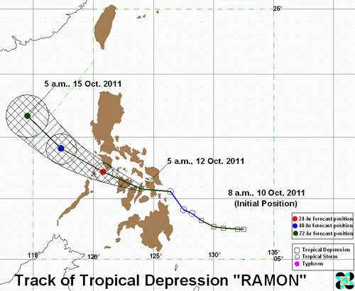
At 7:00 AM today, the center of Tropcial Depression "Ramon" was estimated at 80km North of Cebu. Having a speed of 15kph, "Ramon" move West to Northwest and is expected to be at 40km Southwest of San Jose, Occidental Mindoro by tomorrow morning and at 400km West Northwest of Calapan, Oriental Mindoro by Friday morning. By Saturday morning, it will be at 470km West of Iba, Zambales.
PAGASA lowers the Storm Signal from No. 2 to No. 1. The following are affected areas with Storm Signal No. 1 (wind speed is 45-60kph):
LUZONTropical Depression "Ramon" may break twigs and branches of trees. Some banana plants may tilt or land flat on the gournd. Rice in flowering stage may suffer significant damage. Some nipa and cogon houses may be partially unroofed. Sea travel of small seacrafts and fishing boats is risky.VISAYAS
- Marinduque
- Mindoro Provinces
- Romblon
- Camarines Sur
- Southern Quezon
- Catanduanes
- Albay
- Burias Island
- Sorsogon
- Ticao Island
- Masbate
- Coron Island
MINDANAO
- Samar Provinces
- Leyte Provinces
- Cebu
- Bohol
- Panay Island
- Guimaras
- Negros Provinces
- Siquijor Island
- Agusan del Norte
- Surigao del Sur
PAGASA now lowers the Public Storm Warning Signals elsewhere.
- https://www.affordablecebu.com/