Fault is a planar fracture in a volume of rock, across which there has been significant displacement along the fractures as a result of earth movement. This earth movement is what we called tectonic forces that compress the land.
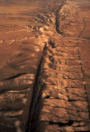
Example of a fault line is the San Andreas fault in the Carrizo Plain, Central California, USA which can be seen in the photo below.

San Andreas fault aerial view
Faults in the Philippines
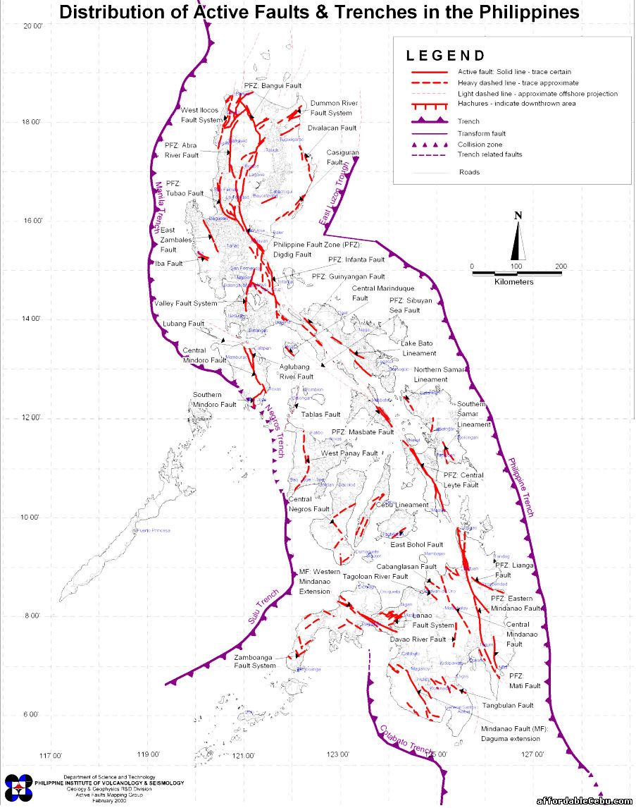
In the Philippines, the main fault runs most of the length of the country. This is called the Philippine fault. It extends from Bangui, Ilocos Norte in the north, crosses Zambales, Digdig, Central Marinduque, and traverses Central Leyte province and up to Mati.
In northwest Luzon, the fault has become braided or composed of many strands and is no longer single. The Philippine Fault, probably active since the Middle Miocene is a recent example of the north-south strike-slip fault zones of Luzon.
Following the major 1990 Luzon earthquake, scientists reconsidered their fault models and following the lead of Pinet and Stephan (1989), thought it likely that Benham Plateau is still displacing central Luzon and the Philippine Fault System to the west, and so caused the 1990 Luzon earthquake. The 20 second or 50 second wave in the 1990 quake developed a new east-west sub-fault, which terminated disastrously at Baguio.

Map of Faults and Trenches in the Philippines
List of Faults in the Philippines
- Bangui Fault
- West Ilocos Fault System
- Dummon River Fault Sytem
- Abra River Fault
- Divalacan Fault
- Tubao Fault
- Casiguran Fault
- East Zamabales Fault
- Iba Fault
- Digdig Fault
- Infanta Fault
- Guinyangan Fault
- Valley Fault System
- Central Marinduque Fault
- Lubang Fault
- Sibuyan Fault
- Central Mindoro Fault
- Aglubang River Fault
- Lake Bato Lineament
- Southern Mindoro Fault
- Northern Samar Lineament
- Tablas Fault
- Masbate Fault
- Southern Samar Lineament
- West Panay Fault
- Central Negros Fault
- Cebu Linemanet
- Central Leyte Fault
- East Bohol Fault
- Cabanglasan Fault
- Tagoloan River Fault
- Lanao Fault System
- Davao River Fault
- Lianga Fault
- Eastern Mindanao Fault
- Central Mindanao Fault
- Mati Fault
- Tangbulan Fault
- Mindanao Fault Daguma Extension
- Zamboanga Fault System
Trenches in the Philippines
The Philippine Trench (also called Philippine Deep, Mindanao Trench, and Mindanao Deep) is an underwater trench to the east of the Philippines. It has a length of approximately 1,320 km (820 mi) and a width of about 30 km (19 mi) from the centre of the Philippine island of Luzon trending southeast to the northern Maluku island of Halmahera in Indonesia. Its deepest point, the Galathea Depth, has a depth of 10,540 metres (5,760 fathoms; 34,600 feet). Before 1951, when an expedition of HMS Challenger measured a depth of 10,863 metres (5,940 fathoms; 35,640 feet) in the Mariana Trench, the Galathea Depth was the greatest known ocean depth. Now, it's the deepest point in the country and the 3rd in the world.
Immediately to the north of the Philippine Trench is the East Luzon Trench. They are separated, with their continuity interrupted and displaced, by Benham Plateau on the Philippine Sea Plate.
The Philippine Trench is the result of a collision of tectonic plates. The Philippine Sea Plate is subducting under the Philippine Mobile Belt at the rate of about 16 cm (6.3 in) per year.
List of Trenches in the Philippines
- East Luzon Trench/Trough
- Manila Trench
- Negros Trench
- Sulu Trench
- Cotabato Trench
- Philippine Trench
Is your place located along the fault lines? What's your plan if the fault will move or if an earthquake will hit your place and destroy your home?